Fishing villages, stone carvings, coral reefs, cliffs, mackerel
Bohuslän is located in Götaland (southeastern Sweden), being with its 4 528 km² (1,1% of the whole country) the 19th (of 25) biggest province and the westernmost province. Here we have the westernmost point(s) of Sweden: the island of Stora Drammen in the archipelago of Kosterislands (Kosteröarna). The westernmost point on the mainland is though Stensvik, close to Strömstad. Bohuslän includes only one county and it belongs to the diocese of Göteborg. It has a population of ca 305 000 inhabitants (10th place of 25), thus having a density of ca 68 inhabitants/km².
The highest point is Björnerödspiggen in Strömstad kommun (northern Bohuslän) with 222 m. The biggest lake is Bullaresjön (ca 17 km², altitude of ca 40 m), located in the central eastern part. The plant symbol of the province is the honeysuckle (vildkaprifol) and the animal symbol is the common seal (knubbsälen). Other symbols: the European oystercatcher bird (strandskata), the Atlantic mackerel fish (makrill), the musk beetle insect (myskbock), the apple sort Vese, the angel wing mushroom (öronmussling), the vax moss (vaxmossa), the rock type Bohus granite (Bohusgranit) and the element of chlorine (klor/Cl).
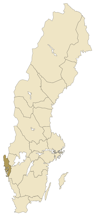
Source: https://upload.wikimedia.org/wikipedia/commons/7/7f/Sverigekarta-Landskap_Bohusl%C3%A4n.svg
Source: https://upload.wikimedia.org/wikipedia/commons/d/db/Bohusl%C3%A4ns_vapen.svg
Bohuslän consists only of one county (län), Västra Götaland. Bohuslän has 13 municipalities, 85 registration districts and 98 urban areas. Here you can find information all municipalities in Bohuslän. Click on the name in order to go further and read more about places to visit and things to do in Bohuslän.
Följ min blogg
Få nytt innehåll direkt till din inkorg.
